Building in an area with a history of coal mining? Don’t let hidden risks threaten your project. A Coal Mining Risk Assessment is essential to identify whether your site suffers from potential ground instability, and coal mining related hazards that could impact construction. Our expert Geotechnical Consultants provide in-depth analysis and practical solutions to help you mitigate risks and build with confidence.
Our Coal Mining Risk Assessment Reports are ready to be sent to your Local Authority to support your planning application.
Contact your local Sub Surface Office for a quote.
Do I Need a Coal Mining Risk Assessment?
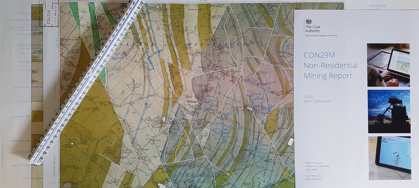
Eleven percent of Britain sits on a coalfield, and if your site is within a “Coal Mining Reporting Area,” you will need to obtain a Coal Authority Mining Report. If you do not already have one for your site, we can obtain a Consultant’s Coal Authority Mining Report for you.
You can check if your site is in a Coal Mining Reporting Area by clicking the link and viewing the Mining Remediation Authority Interactive Map Viewer.
Using its extensive mining records, the Coal Authority has classified the coalfield into two areas based on the degree of risk:
- Development Low Risk Area – This area covers 85% of the coalfields, where coal mining has occurred but poses “low risk” to public safety or ground stability for a standard development.
- Development High Risk Area – This area covers 15% of the coalfields and contains recorded coal mining legacy risks that pose a public safety and/or ground instability risk to the surface.
If your site is in a Coal Mining Reporting Area, we recommend contacting your regional Sub Surface office. Our friendly Contracts Managers will be happy to advise whether you require a Coal Mining Risk Assessment and the best way to proceed to ensure a safe development.
What is a Coal Mining Risk Assessment?
A Coal Mining Risk Assessment is a desk-based study to identity potential site-specific coal mining risks that may affect public safety and ground instability of a site. The CMRA should identify coal mining features, such as:
- Mine entries (shafts and adits)
- Shallow coal workings (recorded and unrecorded)
- Workable coal seam outcrops
- Mine gas
- Recorded coal mining related hazards
- Geological features
- Former Surface Mining sites (Opencast workings)
To identify the coal mining features and assess the risks posed by historical coal mining, our experienced Geotechnical Engineers analyse a range of information including:
- Coal Authority Consultants Coal Mining Report
- 1:10,560 / 1:10,000 scale Geological Maps
- British Geological Survey
- Previous site investigations.
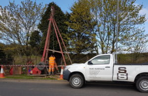
Where the Coal Mining Risk Assessment cannot provide sufficient evidence to rule out the risks posed by past coal mining, the report will recommend an intrusive investigation. This often involves rotary open hole drilling of boreholes to further assess these risks, but it may also include rotary core drilling and trial trenching.

Coal Mining Risk Assessment in Scotland - Geological Map
Coal Mining Features Which Pose a Risk to Development
The most common coal mining features which can pose a risk to the safety and stability of a site include:
- Shallow (Recorded and Unrecorded) Mine Workings
Development High Risk Areas potentially contain recorded shallow workings and probable shallow mine workings. Where no shallow mine workings are recorded but there is known to be a coal seam of workable thickness beneath the site, there is a risk of unrecorded shallow mine workings.
Where coal mining has occurred at shallow depths, there is a risk of surface instability when the collapse of mine workings migrates upwards to the surface.
Shallow (recorded and unrecorded) mine workings can cause several issues, including:
- Ground Instability
- Structural Damage
- Surface Collapse (crown holes)
- Drainage issues
- Gas emissions
- Mine Entries
Mine entries are access points to underground mine workings, including mineshafts (vertical) and adits (horizontal or sloped tunnels). They were used to transport minerals, miners, ventilation and drainage.
The Coal Authority have approximately 171,000 recorded mine entries on their system. The information on recorded mine entries is variable from full details with the exact location and treatment details to no details other than an approximate location. There are also many unrecorded mine entries where the location and conditions are unknown.
Many mine entries were improperly treated and backfilled, and can cause the following risks to development:
- Ground collapse and subsidence
- Gas emissions
- Water ingress and contamination
- No build zones
- Mine Gases
Abandoned mine workings can release hazardous gases such as methane, carbon dioxide, carbon monoxide, oxygen deficient air and hydrogen sulphide, etc.. These can migrate to the surface and accumulate in confined spaces, posing health, asphyxiation and explosion risks.


What Happens After the Coal Mining Risk Assessment?
The desk-based Coal Mining Risk Assessment will evaluate the relevant information and assess the risks posed by historical coal mining. If the risks from coal mining can be mitigated, an intrusive ground investigation will not be required, subject to the agreement with the Local Authority, Planning, Coal Authority and Warranty Providers.
Where the Coal Mining Risk Assessment cannot provide sufficient evidence to rule out the risks posed by past coal mining, the report will recommend an intrusive ground investigation to further evaluate the risks. Details of how common coal mining features are investigated include:
- Shallow (recorded and unrecorded) Coal Seams – Rotary open hole or core drilling to prove the depth and thickness of any intact or worked coal seams.
- Mineshafts on site – Trial trenching or rotary probing to determine the exact location of the mineshaft. The mine shaft can then be drilled to the base to assess the depth and status of the mineshaft.
- Mineshaft off site – Boreholes to determine the depth to rockhead to determine the risk and collapse zone. Trial trenching and rotary probing may be required on site should the mineshaft departure zone cover a section of the site.
- Mine Gas – Ground gas monitoring standpipes can be installed and monitored.
Permissions from the Mining Remediation Authority must be obtained before entering or disturbing coal mines. These take 20 plus working days to obtain but they also offer an expedited service of 10 working days and an express service of 5 working days.
The findings of the ground investigation will determine whether there is a risk from coal mining legacy. If there is, recommendations and/or remediation measures will be detailed to ensure safety and stability of the development.
For more information please see our page on Ground Stability – Mining and Natural Cavities or contact us directly.


A Brief History of Coal Mining in the UK
Around 11% of the Britain sits on a “coalfield,” meaning that the bedrock contains coal strata. Coal has been mined at the surface for centuries; however, the Industrial Revolution of the 18th Century led a rapid increase in both surface and underground mining operations.
It wasn’t until the Inspection of Coal Mines Act of 1850 that there was any requirement for mine plans to be created, and not until the Coal Mines Regulation Act of 1872 that regulations for recording abandoned mine workings were introduced. Under these regulations, all abandoned mine plans had to be supplied to the Secretary of State.
The Coal Industry Act of 1994 led to the formation of the Coal Authority, which became responsible for licencing coal mining and managing safety issues arising from past coal mining. The Coal Authority holds all records relating to coal mining in the UK. However, many unrecorded mines still exist, with no available information.
In December 2015, all underground coal mining in the UK ceased with the closure of the Kellingley Colliery in Yorkshire.
In November 2024, 30 years after its founding, the Coal Authority changed its name to the Mining Remediation Authority to reflect its broader role in mining remediation across the UK. This is a very recent change, and in many places, it may still be referred to as the Coal Authority.
Request a CMRA Quote
If you would like a quote for a Coal Mining Risk Assessment individually or as part of a Desktop Study, please contact your Regional Sub Surface Office.

Other Common Types of Reports: Phase 1 Desktop Study, Phase 2 Ground Investigation, Remediation Strategy, Validation Report
Coal Mining Risk Assessment FAQ
Do I have to have a Coal Mining Risk Assessment?
If your site is in a “Development High Risk Area,” or if the Coal Authority Mining Report indicates a risk from coal mining, or if we believe there is potential for unrecorded mine workings or mine entries beneath the site, a Coal Mining Risk Assessment will be required as part of planning and/or Building Regulations.
Building Regulations 2000 require buildings to be constructed so that ground movement caused by subsidence will not impair the stability of any part of the building.
Who are the Mining Remediation Authority (Formerly the Coal Authority)?
The Mining Remediation Authority, formerly the Coal Authority, are a regulatory body to ensure safe and sustainable development by managing risks associated with mining legacies while also considering the protection of remaining coal and other mineral resources.
Local planning authorities are required to consult the Coal Authority on individual planning applications, using a risk-based approach to classify coalfields into Development High Risk Areas and Development Low Risk Areas.
Why isn’t a Coal Authority Mining Report sufficient?
A Coal Authority Mining Report is a factual report of known coal mining information. It is not an assessment of the risks the coal mining features pose to the site and development.
How much is a Coal Mining Risk Assessment?
The cost can vary depending on the size, location and complexity of the site. Contact your Regional Sub Surface office for a quote.
What areas often require a Coal Mining Risk Assessments?
A Coal Mining Risk Assessment is often required in parts of Lancashire, Greater Manchester, Cumbria, Yorkshire, Derbyshire, West Midlands, Staffordshire, Northumberland, Durham, Scotland, Wales, etc. This is not an exhaustive list!
View some of our Related Blog Posts:
What is a Phase 1 Desk Study?
What is a Phase 1 Desk Study? A Phase 1 Desk Study is a preliminary [...]
02
Aug
Aug
What is a Site Investigation?
What is a Site Investigation? A Site Investigation is an intrusive investigation aimed at assessing [...]
23
Jun
Jun